Gökçeada (Imbros) Geography: Natural Structure & Land Features
- Gökçeada (Imbros) is Turkey's largest island at 286 km²
- Highest point: Doruk Tepe at 673 meters
- Windy approximately 300 days a year
- Ranks first in the Aegean for freshwater resources
- Volcanic in origin, separated from the mainland 12,000 years ago
- Home to Turkey's only Underwater National Park
Living on Gökçeada means feeling geography deeply, not just reading about it. When I open my window on a winter morning, the northeasterly wind whipping off the sea stings my face; on a summer evening, the silhouette of Doruk Tepe turns crimson — these are everyday occurrences here. Turkey's largest island, this landmass of 286 km² has carved out its own world in the northeastern Aegean. Known historically as Imbros, it lies northwest of the Dardanelles, west of the Gallipoli Peninsula. Stretching 29.5 km from east to west and 13 km from north to south, it is surrounded by 92 km of coastline.
| Info | Details |
|---|---|
| Area | 286 km² |
| Highest point | Doruk Tepe, 673 m |
| Coastline | 92 km |
| Population (2023) | 10,721 |
| Climate | Mediterranean (Marmara influence on north coast) |
| Windy days | ~300 days per year |
| Distance to Kabatepe | 14 nautical miles |
| Ferry duration | ~75 minutes |
| Special title | World's first Cittaslow island (2011) |
Terrain and Doruk Tepe
As the ferry approaches the island, the first thing you notice is the ruggedness of the hills. If you're expecting a flat island, you're mistaken. 77% of Gökçeada is mountainous, 12% is rugged, and only 11% is flat. I only truly understood these proportions after years of hiking; when you climb from the central villages northward, the slopes suddenly steepen, while heading south, the terrain softens.
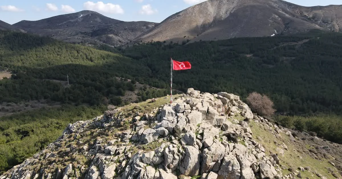
Doruk Tepe: 673 Meters
The island's highest point, Doruk Tepe, stands at 673 meters, dominating everything around. I climbed to the summit one autumn day; the silhouette of Samothrace Island was visible on the horizon, and the southern beaches below looked like miniatures. On a clear day, you can even see Gallipoli. There are 14 named mountains and hills on the island, but Doruk Tepe is the boss of them all.
Village Locations: Strategy Against the Wind
The island's villages weren't placed randomly. Tepeköy, Zeytinliköy, Dereköy — all are nestled at the foot of sheltered hills. Why? Because the winter northeasterly wind blows so hard that any exposed structure can't withstand it. This is a settlement strategy honed over centuries. Bademli Village even leans toward the harbor, turning its back to the wind.
Coastlines: Rugged North, Gentle South
The coastal character of Gökçeada changes completely between north and south. On the north and northeast, volcanic cliffs drop steeply into the sea. Between them lie hidden pebble coves accessible only by sea or hiking trails. Getting there requires adventure, but the reward is great.
To the south, a completely different island awaits you. Wide, fine-sand beaches stretch out:
- Aydıncık (Kefaloz): Fine sand, shallow entry — the most comfortable beach for families. Approximately 1,200–2,000 meters long.
- Kuzulimanı: Near the ferry dock, a 2–3 km wide sandy beach. Facilities available.
- Yıldızkoy: Turkey's only Underwater National Park is here. Rocky terrain, perfect for snorkeling.
- Marmaros: Pebble and rocky, water crystal clear like an aquarium, but don't enter without water shoes.
- Uğurlu (Secret Harbor): As the name suggests, untouched and quiet.
- Kapıkaya: Rocky structure, free and uncrowded.
Last summer, a neighbor who first went to Marmaros without water shoes returned after five minutes. The stones are merciless, but once in the water, you swim among fish. Parking is tricky but worth it. You can learn more about Marmaros's unique nature. For exploring Gökçeada's northern shores, consider Kapıkaya Beach. You can also stop by Uğurlu Beach to watch the sunset. Find more about Gökçeada beaches.
Climate and Wind: The Island's True Character
No day passes on Gökçeada without talking about the weather. Because it sits at the mouth of the Saros Gulf, the wind blows about 300 days a year. Don't think this is an exaggeration — in winter you can't hang laundry, and in summer, without the wind, you'd suffocate from the heat.
Temperatures range between 4°C and 29°C throughout the year. Summers are hot and dry but not oppressive thanks to the breeze. Winters are long, cold, and rainy. The driest month is August (around 3 mm rainfall), and the wettest is December (110 mm).
Poyraz and Lodos: Two Bosses
In winter, the poyraz (northeasterly wind) comes from the northeast, harsh and gusty. Cold air masses descending from Russia choose Gökçeada as their first stop. Lodos (southwesterly wind) is different: it blows from the southwest, warm but can reach speeds of 50–60 knots. Ferry cancellations are most often due to lodos. If you're visiting in winter, definitely have a backup plan — getting stranded is a classic island story. It's wise to check current ferry schedules.
In summer, northerly breezes create a cooling effect. This is why the island is a favorite among windsurfers — what seems like a downside is actually one of its biggest attractions.
Volcanic Origins and Geological Structure
Imbros's story goes back 20,000 years. At that time, the island was connected to the mainland, even forming a single large landmass with Lemnos to the south. 12,000 years ago, melting glaciers raised sea levels, and Gökçeada broke away from the mainland. These volcanic lands contain some of the oldest rocks in the Aegean.
In the north, very old formations like the Çamlıca Metamorphites (from the Late Ediacaran period) surface, while to the south, younger volcanic rocks — andesite, basaltic andesite lavas — become widespread. Andesite rock around Dereköy has been used as building stone for centuries; you can still see these rocks in the stone walls of old Imbros houses.
There are also hanging streams in the north — stream beds that have lost their normal flow paths due to tectonic uplift, appearing suspended in mid-air. Under the influence of the North Anatolian Fault, the north of the island rises while the south subsides. Hence the steep northern coasts and gentle southern shores.
Water Resources: The Richest Island in the Aegean
Gökçeada is considered first among Aegean islands in terms of freshwater resources, and fourth in the world. It is described as one of five self-sufficient islands globally — low external dependency in water, agriculture, and natural resources.
The island's largest stream, Büyükdere, feeds the Zeytinli Dam (1977–1983), which irrigates 700 hectares and supplies 1 hm³ of drinking water annually. There are five lakes in total, but the most interesting is Tuz Gölü (Salt Lake). This lagoon near Aydıncık beach formed by a double tombolo. In summer, it dries up completely, leaving a white salt crust — a photographer's delight. Its sulfurous mud is used for skincare, but don't expect miracles; the smell is strong.
One thing to note: there are no large perennial streams on the island. Most streams dry up in summer. Don't be surprised if a stream bed that rages in winter is just cracked earth in summer.
Marine Biodiversity and Conservation
Gökçeada's waters host the richest marine life in the Aegean. Turkey's only Underwater National Park at Yıldızkoy has been protected since 1999. Its waters are home to 144 fish species, 34 sponge species, 17 cephalopod species, and 8 marine mammal species. Posidonia oceanica (endemic seagrass) meadows cover the seabed.
Critically endangered Mediterranean monk seals (Monachus monachus) and endangered loggerhead sea turtles (Caretta caretta) are also seen in these waters. Lava rocks and underwater caves are the submarine continuation of the island's volcanic past. Diving and underwater activities require special permits.
And one more thing: İncirburnu Cape is on Gökçeada and is Turkey's westernmost point. On a map, it looks like an ordinary cape, but standing there, the feeling that "there's no Turkey beyond this point" is something else.
Frequently Asked Questions
How big is Gökçeada?
With an area of 286 km², it is Turkey's largest island. It stretches 29.5 km from east to west and 13 km from north to south. The coastline is 92 km long.
Why is Gökçeada so windy?
The island is located at the mouth of the Saros Gulf, making it very exposed to winds. It is windy about 300 days a year. In winter, the poyraz (northeasterly) dominates; in summer and autumn, the lodos (southwesterly) prevails. This makes the island ideal for windsurfing but can also cause ferry cancellations.
Is Gökçeada a volcanic island?
Yes, Gökçeada is volcanic in origin. It was connected to the mainland 20,000 years ago and separated 12,000 years ago due to melting glaciers. Volcanic rocks from different periods, lava formations, and underwater caves bear traces of this past.
Is there a freshwater shortage on Gökçeada?
No, Gökçeada ranks first among Aegean islands in freshwater resources. The Zeytinli Dam meets the island's water needs. However, most streams dry up in summer, causing seasonal fluctuations.
What is the highest point of Gökçeada?
Doruk Tepe, at 673 meters, is the island's highest point. From the summit, you can see the island panorama, southern beaches, and, on clear days, Samothrace Island.
📍 Merkez (Çınarlı) — Harita
📍 Bu Bölgedeki İşletmeler
🍽️ Yeme & İçme
🏷️ Etiketler: