Gökçeada Marmaros Waterfall: Access, Guide & Tips
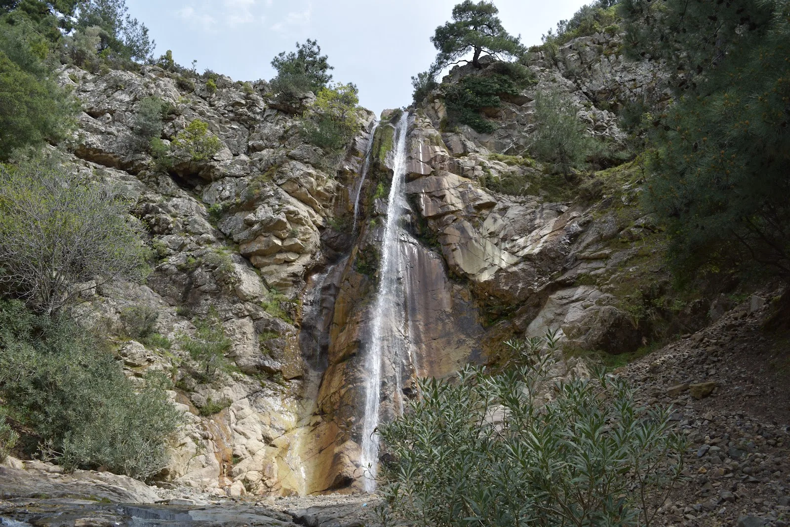
Imagine a waterfall hidden deep in a red pine forest on Gökçeada's north coast: a 38-meter white curtain of water, flanked by centuries-old pines, mossy rocks below, and light filtering through the canopy. This is Marmaros Waterfall—one of the island's least known yet most enchanting natural treasures. The challenge of reaching it is richly rewarded.
Where is Marmaros Waterfall?
Marmaros Waterfall is located in the northwestern part of Gökçeada (Imbros), about 2 km inland from Marmaros Bay. Administratively, it lies within the boundaries of Gökçeada district, Çanakkale Province, near the village of Dereköy. GPS coordinates: 40.1812201, 25.7679154 (Tepeköy/Gökçeada/Çanakkale).
It is a natural cascade formed by a stream fed by Teyfik Bey Hill (682 m), the island's highest point. The stream descends through pine and oak forests before plunging 38 meters over a rocky cliff into a rocky pool below. About 50 meters behind the main waterfall, there is a smaller 3-meter cascade—so visitors encounter two different waterfalls along a single trail.
Physical Features of the Waterfall
| Feature | Value |
|---|---|
| Main waterfall height | 38 meters |
| Small waterfall height | ~3 meters |
| Distance between falls | ~50 meters |
| Water source | Stream from Teyfik Bey Hill (682 m) |
| Flow regime | Seasonal (high in winter-spring, dry in summer) |
| Surroundings | Dense red pine and oak forest |
| Geology | Andesite and granitic rocks |
How to Get to Marmaros Waterfall?
First, you need to reach Gökçeada. The island is accessible by ferry from Çanakkale or Kabatepe piers.
Getting to Gökçeada
- Take a bus or flight to Çanakkale from Istanbul, Izmir, or Ankara.
- Go from Çanakkale to Kabatepe Port (about 30 km).
- Take the Gökçeada ferry from Kabatepe (about 1 hour 30 minutes).
Getting to the Waterfall on the Island
Follow this route step by step:
- From Gökçeada center, follow the route to Uğurlu Village → Dereköy.
- At the exit of Dereköy towards Uğurlu, turn right onto the forest road.
- Continue about 7 km on the asphalt road; then park your vehicle (the last 2 km are rough dirt/stone, not recommended for cars).
- Walk along the forest trail for about 20–30 minutes; you'll first see the small cascade, then the main waterfall.
Vehicle warning: The dirt road can seriously damage the undercarriage of a standard car. A 4x4 or high-clearance SUV is strongly recommended. For the last 2 km, it's safest to proceed on foot regardless of vehicle type.
By bicycle: It's possible to reach Marmaros Waterfall with a mountain bike, but you'll need to dismount and walk the last 100–200 meters of narrow, steep trail. Among Gökçeada's cycling routes, there is a 62 km loop that includes the waterfall (with 1,160 meters of elevation gain, suitable for intermediate to advanced cyclists).
GPS and Map Info
Signage to the waterfall is poor. Even if you follow the brown sign reading "Marmaros 7," you might still go the wrong way. There is no cell phone signal in the area. Therefore:
- Download GPS maps in advance and use an offline map app.
- A recorded hiking route titled "Marmaros Şelalesi Gökçeada" (ID: 6284397) is available on Wikiloc—download it beforehand to make your trip much easier.
- For geocaching enthusiasts, there is a traditional cache (GC6H18X) in the area.
Best Time to Visit
The ideal period to visit Marmaros Waterfall is late March to early May. During this time:
- Water flow is at its peak; the waterfall is fully magnificent.
- The forest is green, and endemic flowers are in bloom.
- The weather is comfortable for hiking (15–22°C).
- The fire ban has not yet started.
Alternatively, after the first rains in November–December, the waterfall becomes active again; however, expect wet trails and muddy ground.
Period to Avoid: Summer
During the summer months (June to October), there are two major issues: First, due to forest fire risk, the Forest Administration closes access to the area—the road at the Dereköy exit may be blocked by a chain. Second, the stream's flow decreases significantly; in some years, the waterfall dries up completely. If you plan to go in summer, call Gökçeada Municipality (+90 286 887 30 52) in advance to confirm road conditions.
Marmaros' Geological Secret: 26-Million-Year-Old Granite
What sets Marmaros Waterfall apart from ordinary waterfalls is the unusual geological structure over which it flows. In scientific literature, this rock group is called the "Marmaros Magmatic Assemblage", dating back to the Late Oligocene period—about 26 million years ago. These granitic plutons intruded into the Karaağaç Formation and have been the subject of international academic studies in geochronology, geochemistry, and tectonic setting.
The waterfall is a geomorphological feature formed by water cascading over this ancient granitic and andesitic bedrock. In the valley, you can also observe the following tectonic formations:
- Hanging valleys (the main geomorphological structure forming the waterfall)
- Raised terraces and ancient coastal notches
- Travertine formations
- NE-trending fault scarps
These formations are evidence that the region has undergone active uplift within the extensional-shear tectonic framework of the North Anatolian Fault. The name "Marmaros" comes from the Greek word for "shining stone," referring to the bright-surfaced granitic rocks in the area. The same root gives Italian "marmo" (marble) and Turkish "mermer" (marble).
Forest Ecosystem: A Nature Compared to a Tropical Paradise
The entire valley leading to Marmaros Waterfall is covered with dense red pine (Pinus brutia) forest. This forest, one of the healthiest red pine habitats in Turkey, is enriched with oak and juniper species. Some sources emphasize that the waterfall's endemic plant diversity resembles "a tropical paradise"—and this comparison is not an exaggeration.
The hike to the waterfall is one of the most enjoyable among Gökçeada's trekking routes.
Endemic Plants Blooming in Spring
- Mountain thyme (Origanum vulgare and endemic subspecies)
- St. John's wort (Hypericum perforatum)
- Rockrose (Cistus species)
- Various orchid species (recorded in the island's flora)
- Moss and fern formations on rocky surfaces
Gökçeada is one of four islands in Turkey with abundant freshwater sources. This feature allows water-dependent plant species to be unusually rich on the island. The area around the waterfall pool, thanks to its constantly moist environment, hosts a particularly lush vegetation.
Fauna
Species observed in the area include falcons (Falco species), swallows, owls, hares, foxes, hedgehogs, and various lizard and snake species. Since Gökçeada lies on the Aegean migration corridor, it is especially rich for birdwatching during March–May and September–November.
Golden Photography Guide
Marmaros Waterfall offers a rare opportunity for photography enthusiasts: the composition of forest, water, and rocks together allows for various photographic approaches.
For tips on capturing the best shots of the waterfall and its surroundings, check out our Gökçeada photography guide.
Best Season for Photos
Ideal period: late March to early May (spring). Water flow is highest; the waterfall is at full volume. The forest is green, endemic flowers are blooming. The weather is cool (15–22°C), comfortable for a long hike.
Best Times of Day
- Early morning (07:00–09:00): Soft light filtering through the forest; ideal for mist and steam effects.
- Afternoon (14:00–16:00): As the sun angle changes, you can catch refracted light on the water curtain.
- Cloudy days: The most suitable light condition for shadowless photos with the waterfall fully illuminated.
Technical Tips
- Long exposure: A tripod is essential for a silky water effect; an ND filter (ND4–ND8) is recommended.
- Wide-angle lens: 16–24 mm can capture the waterfall together with the surrounding forest.
- Macro shots: Moss on rocks, water droplets, and endemic flowers offer macro lens opportunities.
- Camera protection: Water mist is heavy near the waterfall; a rain cover for lens and body is recommended.
- Scale element: A figure standing in front of the waterfall pool creates a sense of scale.
Historical and Mythological Dimension
Gökçeada has been an important Aegean island since ancient times. Homer's Iliad mentions the island; it held a strategic position during the Trojan War and was annexed to Athens by Miltiades around 500 BC. The island passed through the hands of Pelasgians, Athenians, Romans, Byzantines, and in 1455, under Fatih Sultan Mehmet, to the Ottomans, carrying a rich cultural stratification.
The Marmaros region was part of the cultural geography sustained by the island's Greek Orthodox population. After the majority of the Greek population left the island between 1964 and 1970, rural areas became largely deserted; paradoxically, this abandonment helped preserve the forest and keep the waterfall valley undisturbed.
Gökçeada is neighboring Samothrace (Semadirek), associated in Greek mythology with the cult of Hermes and the Cabeiri. Within the framework of ancient belief systems where rock formations, waterfalls, and caves were considered sacred, it is thought that Marmaros Valley may have held special significance.
Things to Know Before Your Visit
Fire Ban and Access Restrictions
During summer (approximately June–October), the forest area around the waterfall is closed to visitors due to fire risk. This decision is made by the Forest Administration; dates may vary from year to year. It may be possible to visit during the closed season with special permission—for this, it is recommended to call Gökçeada Municipality (Tel: +90 286 887 30 52). Unauthorized entry during fire season can result in heavy fines.
Facilities and Infrastructure
There are no facilities, toilets, or shops at the waterfall area. You must bring your own food and water. Use Dereköy for last-minute shopping. There is no cell phone signal; it is recommended to go in a group of at least two and carry a first aid kit.
If you want to shop in Dereköy, you can taste local flavors at Falia Taverna.
Safety Warnings
- The last 7 km of dirt/rock road can damage vehicle undercarriages; a 4x4 or high-clearance vehicle is recommended.
- The final trail section is rocky and steep; sturdy hiking shoes are mandatory.
- Wet rocks can be slippery in winter.
- Do not go alone; form a group of at least two.
Marmaros Waterfall + Bay: Full-Day Route
For those who want to explore Marmaros most efficiently, here is a suggested full-day itinerary:
- 08:00 AM: Depart from Dereköy. Do your last shopping (water, food) here.
- 08:30–09:30: 7 km drive on the forest road. Park at the farthest drivable point.
- 09:30–10:00: Walk the trail to the small cascade.
- 10:00–11:00: Photo and rest break at the main waterfall. Explore the mossy rocks, water mist, and forest atmosphere.
- 11:30–12:30: Descend to Marmaros Bay; swim and have lunch.
- 12:30–14:30: Relax at the bay, snorkel, or explore the cove.
- 15:00: Start your return journey—leave at least 2 hours before sunset.
Practical Information Summary
| Info | Details |
|---|---|
| Entrance fee | Free (public land) |
| Open season | November–May (outside fire ban) |
| Closed season | ~June–October (Forest Administration fire ban) |
| Main waterfall height | 38 meters |
| Vehicle recommendation | 4x4 / high-clearance SUV (last 2 km on foot) |
| Hiking time | 20–30 minutes from parking point |
| Facilities | None—bring all supplies |
| Cell signal | None—offline map mandatory |
| GPS coordinates | 40.1812201, 25.7679154 |
| Wikiloc route | ID: 6284397 |
| Geocache code | GC6H18X |
| Municipality contact | +90 286 887 30 52 |
Frequently Asked Questions
Is Marmaros Waterfall open in summer?
No. The forest area is closed between June and October due to fire ban. Special permission may be obtained; you need to call the municipality.
Is there water at the waterfall? Does it dry up?
In summer, water flow decreases significantly; in some years it may dry up completely. The most vigorous period is spring (March–May).
Can I drive to the waterfall?
No. You must park where the asphalt road ends. The last 2 km are rough dirt road, and a 4x4 is recommended. The final trail is only accessible on foot.
Can I go with children?
The final trail is steep and rocky, making it difficult for small children. Children over 10 who are used to hiking can go without issues.
Are Marmaros Bay and the waterfall the same place?
No, but they are close. The waterfall is about 2 km inland from the bay, inside the forest. Both can be visited on the same trip.
Conclusion: Gökçeada's Best Secret
Marmaros Waterfall is often described in competitor content analysis with a recurring phrase: "Gökçeada's hidden paradise." This description is entirely apt given the difficulty of access, lack of promotion, and preserved nature of the waterfall.
The 38-meter water curtain, amidst a centuries-old pine forest, reminds you of one thing: Some beauties are for those who know how to seek them. Marmaros Waterfall is exactly such a place—a gift for the curious, for those who set out with patience, and for those who know how to be alone with nature.
When considered within the framework of Gökçeada's Cittaslow (Slow Island) philosophy, Marmaros Waterfall is one of the places that best embodies this philosophy: go slow, feel deeply, listen to nature. And remember: the moment you first hear the waterfall's sound in the forest, the excitement to discover Gökçeada's other hidden beauties will make you instantly forget all the hardships of the journey.